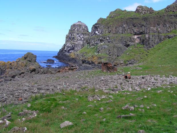
Rathlin Island is a large inhabited marine island situated some 4km from the north Antrim coast of Northern Ireland. There are basalt and chalk cliffs, some as high as 100 metres, as well as several sea stacks on the north and west shores of the island. The south and east shores are more gently sloping with areas of maritime grassland and rocky shore. The length of the coastline is approximately 30 km.
The coastal strip, which is included in the SAC, is of scientific interest because of the wide variety of habitats and associated flora and fauna it contains. These habitats include very high sea cliffs, sea stacks, maritime grassland, saltmarsh and an equally wide range of inter-tidal conditions eg vertical cliff, boulder and shingle shores and wave cut platforms on both chalk and basalt.
Related articles
- Appointment of Deputy Chair and up to 16 Board Members to the Council for Nature Conservation and the Countryside (CNCC)
- ASSI Guidance for Public Bodies/Competent Authorities
- Coastal Areas of Special Scientific Interest
- Conservation and protection enforcement programme
- Conservation Management Plans (CMPs)
- Ecological Surveys
- European Marine Sites - Marine Special Areas of Conservation and Special Protection Areas
- Financial administrative penalties
- Fishing licence points system for serious infringements of the enforcement programme
- Introduction to Conservation Management Plans (CMPs) for Northern Ireland’s Special Areas of Conservation
- Mandatory recording of marine mammal bycatch
- Marine Conservation Zones
- Marine historic environment
- Marine Protected Areas
- Marine Ramsar sites
- Monitoring marine habitats and species
- NI CHART Bluefin Tuna
- Outline Construction Environmental Management Plan (CEMP)
- Portrush Coastal Zone
- Shipwrecks
- Special Areas of Conservation
- Special Areas of Conservation for Harbour porpoise
- Special Protection Areas
