Department of Agriculture, Environment and Rural Affairs Department of Agriculture, Environment and Rural Affairs An Roinn Talmhaíochta, Comhshaoil agus Gnóthaí Tuaithe Depairtment o' Fairmin, Environment an' Kintra Matthers

Main navigation

  • Home
  • Topics
  • Publications
  • Consultations
  • Contact

Translation help

Translate this page

Select a language

  • Arabic — عربي
  • Chinese (Simplified) — 中文简体
  • Chinese (Traditional) — 中文繁體
  • Dutch — Nederlands
  • Filipino — Filipino
  • French — Français
  • German — Deutsch
  • Hungarian — Magyar
  • Irish — Gaeilge
  • Italian — Italiano
  • Latvian — Latviešu
  • Lithuanian — Lietuvių kalba
  • Polish — Polski
  • Portuguese — Português
  • Romanian — Română
  • Russian — Русский
  • Slovak — Slovenčina
  • Spanish — Español
  • Ukrainian — Українська
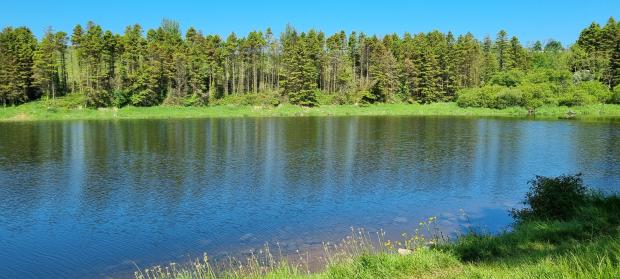
  • Stoneyford Reservoir

    Topics:
    • Angling and Commercial Fishing (Inland Fisheries), 
    • Fisheries in County Armagh

    Wading is permitted but care should be taken. Early season fly fishing with sunk lures and streamers can be effective. This is a public water supply and care should be taken to prevent pollution.

    The presence of Zebra Mussels is still preventing the stocking of fish from Movanagher Fish Farm. For more information, please visit Zebra Mussels and impact on fish stocking in the Public Angling Estate.
     

    Key Information

    Fishery TypeGame
    SpeciesBrown Trout
    Season Open1st March
    Season Close31st October
    Rod Licence12 years old and over DAERA Game Rod Licence
    Permit12 years old and over DAERA Game Fishing Permit
    Fishing methodsFly Fishing, Spinning and Worm Fishing. Restrictions: Angling only permitted between 8.00am - 10.00pm
    Bag LimitFour Stocked Trout minimum length 25.4cm

    Buy a DAERA Licence, Permit or Day Ticket


    Car Parking OnsiteNo
    Disabled Car Parking OnsiteNo
    Fishing StandsNo
    Disabled accessible fishing standsNo
    Boats AllowedNo
    Boat RestrictionsN/A

    Click here for location on Google Maps

    Directions

    • From Lisburn: Head along the Glenavy Road taking a right onto Whinney Hill ontoHuntshill Road; continue along Huntshill Road.
    Local Council AreaLisburn & Castlereagh
    Nearest populated areaLisburn
    Water TypeReservoir
    Water Area / Size55 Hectacres

    Related content

    • Carnagh Forest Lakes
    • Clay Lake
    • Craigavon City Park Lake - North
    • Craigavon City Park Lake - South
    • Gentle Owens Lake
    • Loughgall Lake
    • Seagahan Reservoir
    • Upper Bann River
    Share this page Share on Facebook (external link opens in a new window / tab) Share on X (external link opens in a new window / tab) Share by email (external link opens in a new window / tab)

    Department footer links

    • Crown copyright
    • Terms and Conditions
    • Privacy
    • Cookies
    • Accessibility
    • The Northern Ireland Executive
    • The Executive Office
    • Department of Agriculture, Environment and Rural Affairs
    • Department for Communities
    • Department for Education
    • Department for the Economy
    • Department of Finance
    • Department for Infrastructure
    • Department for Health
    • Department of Justice
    • nidirect.gov.uk — the official government website for Northern Ireland citizens